When severe weather threatens, most people check their phone, pull up a radar app, and feel like they have the full picture. They don’t.
Weather radar is a powerful tool — but it has a blind spot that misses everything from 5,000 feet in the air all the way down to the ground where you live. Filling that gap is the job of storm spotters, and what they do matters more than most people realize.
What Doppler Radar Cannot See
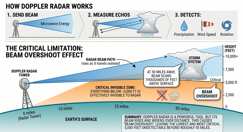
Doppler radar works by sending out a beam of microwave energy and measuring what bounces back. It can detect precipitation, estimate wind speed, and identify rotation in a storm — all from a distance of hundreds of miles. That sounds comprehensive, but there’s a fundamental limitation baked into the physics.
As the radar beam travels outward from the tower, it rises. By the time it reaches storm systems 50 to 100 miles away, the beam is scanning thousands of feet above the surface. Meteorologists call this beam overshoot, and it means that everything happening below roughly 5,000 feet is effectively invisible to radar.
That 5,000-foot gap is not empty sky. It is where tornadoes touch down, where flash flooding begins, where hail reaches the ground, and where the difference between a warning and a confirmed emergency is decided. Radar can tell forecasters that conditions are favorable for a tornado. It cannot tell them whether one is actually on the ground.
What Storm Spotters Actually Do
Storm spotters are trained people deployed on the ground specifically to observe and report what radar cannot see. They are the ground truth that transforms a radar signature into confirmed, actionable information.
The backbone of storm spotter training in the United States is SKYWARN, a program run by the National Weather Service (NWS). SKYWARN has trained hundreds of thousands of volunteers since the 1970s. These are not hobbyists taking a guess — they are people who have completed formal training in storm structure, hazard identification, and how to relay accurate reports to the NWS in real time.
Many storm spotters hold amateur radio (ham) licenses, and for good reason. When severe weather knocks out cell towers and internet infrastructure, amateur radio keeps working. A licensed spotter with a radio is a reliable communications link precisely when every other link is most likely to fail. That reliability is not an accident — it is built into the system by design.
Why Real-Time Storm Spotter Reports Matter During Severe Weather
The difference between radar data and a spotter report is the difference between a weather model and a witness.
Radar gives forecasters a probabilistic picture — a storm looks like it could produce a tornado. A spotter gives them a confirmed fact — a tornado is on the ground, moving northeast, near a specific road. That distinction directly determines how warnings are worded, how urgently they are issued, and how much time you have to act.
Spotter reports also serve as verification. When the NWS issues a tornado warning based on radar, a spotter confirmation removes any remaining doubt and allows forecasters to escalate the language and urgency of that warning immediately. When no tornado is confirmed on the ground, spotters help prevent over-warning — which matters because communities that receive too many false alarms start to tune them out.
The NWS doesn’t just accept spotter reports — it depends on them. That is a meaningful endorsement. The same agency responsible for official warnings, the agency that runs the most sophisticated weather observation network in the world, has built its severe weather response around the assumption that trained people on the ground will be watching and reporting. That tells you something important about what radar alone cannot do.
How to Get Real-Time Severe Weather Information in Arkansas
In Arkansas, SKYWARN spotters coordinate through organized amateur radio nets during severe weather events. A net controller manages incoming reports from spotters in the field and relays that information directly to the National Weather Service. In some cases, the net controller is stationed on-site at the NWS office in Little Rock, putting verified ground observations in front of forecasters the moment they come in.
When the National Weather Service office in Little Rock issues an alert, they broadcast to the Arkansas Wireless Information Network (AWIN). AWIN is a statewide communications system used by Arkansas law enforcement agencies, fire departments, and other first responders, with over 100 tower sites across the state. The NWS broadcasts weather alerts directly over AWIN — making it one of the most reliable and immediate alert delivery systems in Arkansas.
How Can You Benefit?
During active severe weather events, Arkansas Emergency Communications monitors and broadcasts live radio feeds from law enforcement, fire, EMS, and storm spotters across Central Arkansas — including AWIN traffic. The livestream combines that scanner audio with live radar, traffic, and weather data so you can follow an event as it develops, not just react to it after the fact. In recent weather events, the Arkansas Emergency livestream consistently delivered weather alerts two to three minutes faster than local television stations and other “talking heads” on YouTube. Those extra minutes of warning can make all the difference to your safety.
If you want to know what is actually happening on the ground during a storm — not just what the radar suggests might be happening — that is where to be.
Stay Aware. Stay Safe.
Watch the Arkansas Emergency Communications livestream at YouTube.com/@ArkansasEmergency